Underneath the reservoir in the Lake District lies a hidden village (Image: John Eveson/imageBROKER/Shutterstock)
In the heart of a tourist hotspot set against diverse landscapes is a hidden village that resurfaces to reveal its ancient past.
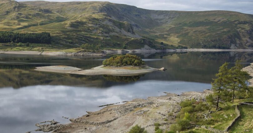
With majestic mountains, forest woodland and stretches of unspoilt landscapes, Haweswater Reservoir is a popular tourist attraction, offering scenic hiking routes and breathtaking vistas around every turn. Yet visitors might not realise that beneath the serene reservoir lies a sunken village that occasionally reappears.
Once a charming and isolated village, Mardale Green is now hidden at the bottom of Haweswater Reservoir in Cumbria’s Lake District. Also known as the ‘Lake District Atlantis’, Mardale Green was a farming village with a church, pub, and houses, alongside its tight-knit community.

Drought at Haweswater Reservoir revealing the old drowned village of Mardale (Image: Getty Images)
However, by 1931, nearby Manchester was home to over 750,000 people, and demand for water increased. As a major solution, the government granted the Manchester Corporation permission to flood and dam the quaint village of Mardale to create Haweswater reservoir, which would supply water to the north west of England.
In August of 1935, the residents of Mardale held their very last church service, which normally held 75 people, and bodies in the churchyard were even exhumed and reburied elsewhere. The church was dismantled, brick by brick, and the village was evacuated in 1935.
There had been widespread opposition to the decision, but ultimately Mardale Green disappeared beneath the water and was replaced by the Haweswater reservoir. However, the village’s history hasn’t been submerged forever, as it reappears from time to time.
The reservoir contains 84 billion litres, but during extreme droughts, remnants of the village break through the water. While many buildings were demolished before the village flooded, the ruins of the old church, pub and house reappear, along with stone walls, the outlines of streets, and a 17th-century humpback bridge, as the water level shrinks.
 Upland reservoir with low water")
The village was evacuated in 1935 and demolished (Image: FLPA/John Eveson/Shutterstock)
The former village lay submerged for decades, but in 1976, following a heatwave, it resurfaced. Since then, it reappears every few years when the reservoir level is below 50 per cent, and many visitors have ventured to the reservoir to witness the ruins of the village.
While some may never get a chance to capture a glimpse of the submerged village, the Haweswater Reservoir remains a popular tourist destination, thanks to its position as the highest and most easterly lake in the Lake District. It also impressively supplies around 25 per cent of northwest England’s water.
There are plenty of enjoyable walking routes around the reservoir, but the two favoured trails are Haweswater and High Street, along with the path circling the lake. The Haweswater to High Street route is a 6.2-mile walk and finishes at the tallest peak in the Far Eastern Fells.
But for those avid ramblers, there’s a more extensive 10-mile route that runs along the edge of Haweswater Reservoir, and takes around five hours to complete. With the area steeped in the history of a former farming village, and incredible landscapes to admire, this might just be the perfect area to explore.
Do you have a travel story to share? Email webtravel@reachplc.com
Source link