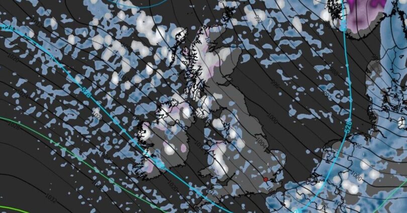
Snow is anticipated to initially arrive early on Wednesday, 25 March morning with maps, created by WXCharts using Metdesk data, displaying numerous large white and grey patches across the UK.
Ensure our latest news headlines always appear at the top of your Google Search by making us a Preferred Source. Click here to activate or add us as Preferred Source in your Google search settings.
Numerous areas can expect snowfall, with the heaviest snow battering the Scottish Highlands.
Cities in the north, including Liverpool and Manchester, are also predicted to welcome some blizzards throughout the day.
The maps indicate the wintry conditions to commence from as early as midnight on Wednesday with possibility of snowfall persisting into the evening.
Scotland is anticipated to be affected the most with accumulations of between two and five centimetres of snow, with up to 10cm on the highest ground.
Later on in the day the south is predicted to see showers, with Cambridgeshire and Essex experiencing showers.
Alongside the white stuff, rain is also anticipated to fall on Wednesday, with many regions likely to see sleet build-up at some point during the day. As well as snowfall, much of the country will need to brace itself for bitter conditions as temperatures take a dramatic U-turn and plunge into the minuses.
Areas forecast snow on Wednesday
- Aberdeenshire
- Angus
- Argyll and Bute
- Cumbria
- Cambridgeshire
- Glasgow
- Gwynedd
- Essex
- Highland
- Moray
- Northumberland
- Norfolk
- North Yorkshire
- Orkney Islands
- Perth and Kinross
- Powys
- Scottish Borders
- Shetland Islands
- Suffolk
The Met Office has also forecast a sudden shift in weather this week, the Express reports.
Steven Keates, Met Office deputy chief forecaster, said: « After a spell of mild and brighter weather, the UK will turn increasingly unsettled in the coming days. A series of weather fronts will bring periods of rain, strong winds and much colder air by midweek. Wednesday could be quite a shock to the system. »
Source link